

Vol. 38 (Nº 21) Año 2017. Pág. 20
Juan David ZULUAGA 1; Diego Alexander ESCOBAR 2
Recibido: 21/11/16 • Aprobado: 18/12/2016
ABSTRACT: The main purpose of this research is getting an understanding of the relation between the geographic location of the largest Shopping Malls and the population induced by them in the city of Manizales. First, information is obtained by GPS devices throughout more than a year. Afterwards, a territorial analysis is developed with a methodology based with accessibility models that use the operational features of Manizales’ transport network. The travel time spent to arrive at a Shopping Mall is calculated, obtaining a Spatial Coverage represented by isochrones curves. In order to get an approach of the influence of the Shopping Malls in Manizales, the results are compared with the social strata of the city, evaluating which consumers are induced the most. |
RESUMO: La visualización de datos de transporte es un campo de investigación en constante crecimiento, el cual se usa en una amplia gama de disciplinas. Su principal objetivo es asociar datos abstractos relevantes para representar y comunicar información en un contexto visual, produciendo nuevos conocimientos y proporcionando la oportunidad de descubrir patrones ocultos en las bases de datos. La investigación sobre el transporte utiliza conceptos y herramientas de otras ciencias, como sistemas de información geográfica, modelización estadística y - recientemente - minería de datos. La visualización de datos se considera como una nueva técnica útil en el transporte, enmarcada dentro de los sistemas inteligentes de transporte ITS. Este artículo propone e implementa tres visualizaciones basadas en la web para analizar los datos de transporte e interactuar con él: "Líneas de deseo" explora los patrones de viaje a partir del análisis de una matriz origen-destino, "Oportunidad acumulada" presenta de forma dinámica los resultados del modelo de accesibilidad acumulada aplicados en la ciudad; “Análisis de Cobertura "presenta un análisis de cobertura a distancia dentro de la red peatonal a las estaciones Megabús de Bus Rapid Transit (BRT). Las visualizaciones que se desarrollaron facilitan el proceso de análisis e interpretación de los datos y permiten al espectador conocer mejor el sistema de transporte en el área estudiada haciendo que los datos se vuelven más comprensibles y accesibles. |
Manizales is the capital city of Caldas (one of the smallest departments of Colombia), lying on the Colombian Central Mountain Range. It is known as having a steer topography, which complicates the communication between different geographical points. For that reason, the location of the Shopping Malls is a fundamental aspect to develop marketing strategies that would enhance the productivity in the region. In this paper, five Shopping Malls are evaluated: Parque Caldas, Fundadores, Multicentro Estrella, Cable Plaza and Sancancio.
In this research, a GIS (Geographical Information System) is used to store the data related with the location of the Shopping Malls that are currently built. Furthermore, sociodemographic information is analysed to establish quantitative comparisons.
GeoMarketing is a “discipline that connect the power of geographic apprehension and analysis with Marketing techniques and insight, aiming to enhance the ultimate goal of the latter: to sell products, services, or ideas. Although the concept of marketing mix has long included ‘Place’ among the four ‘Ps’ (others being Product, Price, and Promotion)” (McCarthy 1960). Geomarketing is defined as a “specific application of the spatial economy” (Latour, 2001). There have been publications since the 1970s that have shown the importance of mapping in marketing decisions (Bell, 1978). This methodology is used to analyze the relation between territorial analyses with marketing aspects, which allows decision makers to visualize marketing strategies in those areas that are most likely to produce better results. The geography of markets constitutes an ensemble of important elements in the realm of marketing for at least four reasons (Jones, 1999):
- Demand varies according to available space and can be measured just as easily in terms of revenue, number of households, budgetary structures of spending, and lifestyles;
- Supply also varies according to available space in those prices, services, the products and available stores vary with location;
- Supply and demand are generally separate, which justifies the role of the retailer, whose job is to overcome this separation by studying the spatial behavior of both consumers and shopping centers, as well as the logistic chain of supplies at regional, national and international levels;
- The majority of economic activities use space and space has a cost. In order to control it better, this space must be decomposed into units of analysis: this division can rest just as easily on politico-administrative considerations as on census units or even zip/postal codes.
An accessibility analysis can demonstrate technically the potentials interaction between different geographical points (Izquierdo, 1994), aiming at identifying the ease or difficulty of reaching a destination through available infrastructure and means of transport (Geurs and Ritsema Van Eck, 2001). Furthermore, an accessibility analysis is regarded as a key aspect of developing the welfare of a region. Countries with better access to raw materials and markets tend to be more competitive and more productive than isolated areas (Linneker, 1997). Many researchers have attempted to fin the relationship between accessibility and economic development (Rietveld and Nijkamp, 1993; Vickerman et al., 1999; MacKinnon et al., 2008 Ribeiro and Silva, 2011).
With regard to the social perspective, it is vital that people have access to different kind of activities, requiring excellent accessibility and provision of a high standard quality of means of transport through suitable transport systems (Farrington and Farrington, 2005)
In order to improve the model, Manizales’ transport network was obtained from the Transport Master Plan, made by National University of Colombia in 2010, and updated with aerial photographs of different sectors of the city. With regard to social stratification, Manizales comprises with six (6) social strata, being stratum 1 the poorest people and stratum 6 the wealthiest people.
The methodology used in this research is made up of four stages: First of all, Manizales’ transport network was updated for accuracy in the model development whereas the data related with the operational features of the network was analyzed and determined. The second stage consisted in calculating the operational speeds on each link of the network. The third stage is related with the calculation of the integral accessibility to each Shopping Mall from any point of the city. The fourth and last stage concerns the estimation of the percentages of population of each stratum covered by the average travel time curves.
GPS devices were installed in different type of vehicles, aiming at gathering enough data to estimate the operational speeds on the transport network. The information collected from the GPS devices specified: data code, location (latitude and longitude), date and time and device accuracy (The available satellites affect the device accuracy, in our case the accuracy was ± 3 meters).
Figure 1 shows the overlap of the GPS data and Manizales’ network. The validation of the data was essential to get an accurate model and consisted in verifying the database structure, coordinate system, time between points of data, format files and so on. In this case, the use of algorithms which allow the data to connect with the links of the network, was fundamental.
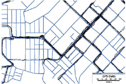
Figure 1. Superposition of the data recollected from the GPS and Manizales’ transport network.
Several methodologies to estimate the operational speed on the network were applied, as this variable affects the general behavior of the network and is a key aspect to estimate the accessibility (Geurs and Ritsema van Eck, 2001). The operational speed was determined for each link of the network through the travel time data collected from the GPs devices. Three parameters were analyzed:
Operational speed between two consecutive points (Ec 1), which permits to establish the deviation of speeds in a particular link. Where Vi = Speed in Km/h; x1, y1= coordinates of point 1 in meters; x2, y2= coordinates of point 2 in meters; and t= time interval between points1 and 2, in seconds.

The average operational travel speed in any link of the network (Ec 2). It shows the relationship between the link length and the passing time difference between the initial node and final node. Where Via= speed I in link a (km/h); ![]() = link length in meters; t1= passing time in the initial node; t2= passing time in the final node.
= link length in meters; t1= passing time in the initial node; t2= passing time in the final node.

The average speed in the link for a period of time (Ec 3), which is used to establish the network impedances to develop the average travel time estimation model. Where Va= average speed on link a; n= number of speed data of link a, for a period of time.

The integral accessibility, measures the interconnection between a particular node to the whole network. An algorithm of TransCAD® software was used to estimate the shortest path between a specific node and the others nodes, getting a matrix which contains the minimum average travel time of each node. Afterwards, the average travel time vector was calculated (Ec 4). Where Tvi= minimum average travel time between node I and the others nodes in the network; ![]() = minimum travel time between node I and node J; n= number of nodes in the network.
= minimum travel time between node I and node J; n= number of nodes in the network.

The average travel time vector (n x 1) is associated with the geographical coordinates (latitude and longitude) of each node. This vector represents the observations in the field, so that it is essential to create a model to estimate the travel time in sectors where speed data is missing. Kriging Method, which is a geostatistical model that estimates the values of travel time of a zone, was used with linear semivariograms as a time prediction prototype for average trips. Five (5) analyses were developed, one for each Shopping Mall.
According to the data provided by the local authorities, the city registers 415.124 inhabitants by 2015 with 97.666 households. The data provided was matched with the isochrones curves estimated with the model, to find the relation between the geographical location of the shopping malls, and the sociodemographic features of Manizales.
Manizales’s transport network is made of 620 Km of roads which are divided in Principal Arterial Streets (9%), Secondary Arterial Streets (15%), Collector’s Streets (15%), Local Streets (46%), Pedestrian Streets (13%) and Semi Pedestrian Streets (7%) (Plan Maestro de Movilidad para la ciudad de Manizales, 2010). The operational speeds obtained by GPs devices showed that the average speed in Principal Arterial Streets is 34 Km/h, Secondary Arterial Streets 23 Km/h, Collector’s Streets 19 Km/h, Local Streets 14 Km/h and in Semi Pedestrian Streets 13 Km/h.
Figure 2, shows the location of the Shopping Malls which are analyzed in this research. It is clearly seen that Multicentro, Cable Plaza and Sancancio are very close in the south-east sector of the city, whereas Parque Caldas and Fundadores are in the West sector of the city.
In Figure 3, The Integral Accessibility from Cable plaza is shown; the isochrones curves are calculated from 5 minutes (green color) to 75 minutes (red color) with intervals of 5 minutes. With regard to the spatial coverage to each stratum, Figure 4, shows that population, who lives in stratum 5 and 6, needs lower travel time to get to the Shopping Mall, whereas population of Stratum 1 and Stratum 4 needs higher travel time. It is clearly inferred that 50% of people of Stratum 5 and 6, need 10 minutes or less, while 50% of people of Stratum 1 and 4 need more than 30 minutes. Interestingly, Stratum 2 is covered faster than Stratum 1, 3 and 4.
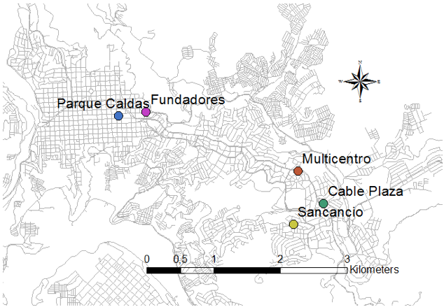
Figure 2 . Shopping malls’ locations.
-----
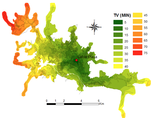
Figure 3 . Isochrones Curves from C.C Cable Plaza
-----
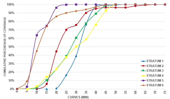
Figure 4 . Percentage of Stratum covered by Cable Plaza
In Figure 5, The Integral Accessibility from Fundadores is shown; the isochrones curves are calculated from 5 minutes (green color) to 65 minutes (red color) with intervals of 5 minutes. With regard to the spatial coverage to each stratum, Figure 6, shows that population, who lives in stratum 1, 2 and 4, needs lower travel time to get to the Shopping Mall, whereas population of Stratum 3 and Stratum 6 needs higher travel time. The graph shows that 50% of people who live in Stratum 4 need 15 minutes to get to the Mall, while 50 % of people who live in Stratum 3 and 6 need more than 25 minutes. According to Fundadores’s location, the Mall’s target is to supply services for people with lower economic sources.
In Figure 7, The Integral Accessibility from Multicentro Estrella is shown; the isochrones curves are calculated from 5 minutes (green color) to 65 minutes (red color) with intervals of 5 minutes. Pertaining to the spatial coverage to each stratum, Figure 8, shows that people, who dwell in stratum 5 and 6, needs lower travel time to get to the Shopping Mall, whereas population of Stratum 1 and Stratum 4 needs higher travel time. Overall, it can be seen that 50% of people of Stratum 5 and 6, need between 10 and minutes, while 50% of people of Stratum 1 and 4 need more than 25 minutes. Interestingly, Stratum 2 is covered faster than Stratum 1, 3 and 4. This results are similar to Cable Plaza’s, as these two Malls are near one of each other.
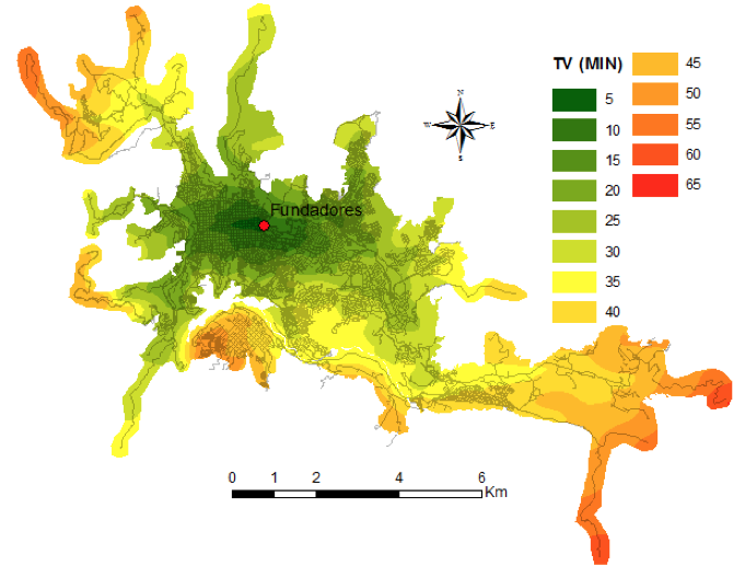
Figure 5 . Isochrones Curves from C.C Fundadores
-----
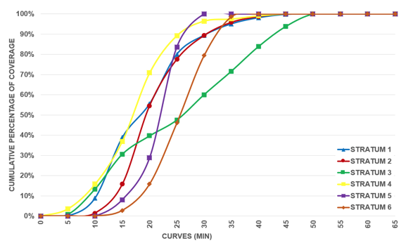
Figure 6 . Percentage of Stratum covered by Fundadores
-----
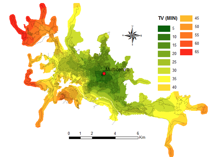
Figure 7 . Isochrones Curves from C.C Multicentro Estrella
-----
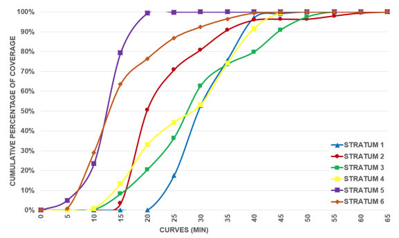
Figure 8 . Percentage of Stratum covered by Multicentro Estrella
In Figure 9, The Integral Accessibility from Parque Caldas is shown; the isochrones curves are calculated from 5 minutes (green color) to 60 minutes (red color) with intervals of 5 minutes.
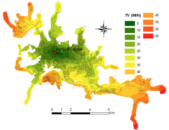
Figure 9 . Isochrones Curves from C.C Parque Caldas
Relating to the spatial coverage to each stratum, Figure 10, shows that population, who lives in stratum 1, 2 and 4, needs lower travel time to get to the Shopping Mall, whereas population of Stratum 3 and Stratum 6 needs higher travel time. The graph shows that 50% of people who live in Stratum 4 need less than 20 minutes to get to the Mall, while 50 % of people who live in Stratum 3 and 6 need more than 25 minutes.
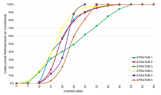
Figure 10 . Percentage of Stratum covered by Parque Caldas
In Figure 11, The Integral Accessibility from Sancancio is shown; the isochrones curves are calculated from 5 minutes (green color) to 70 minutes (red color) with intervals of 5 minutes.
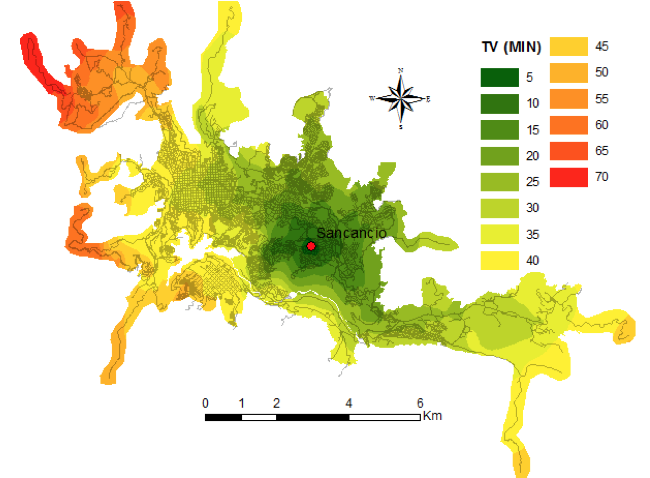
Figure 11 . Isochrones Curves from C.C Sancancio
With regard to the spatial coverage to each stratum, Figure 12, shows that population, who lives in stratum 5 and 6, needs lower travel time to get to the Shopping Mall, whereas population of Stratum 1, 3 and 4 needs higher travel time. It is clearly inferred that 50% of people who lived in Stratum 5 need less than 10 minutes, people from Stratum 6 need more than 10 minutes. By contrast, people who live in Stratum 1 and 4 need more than 30 minutes.
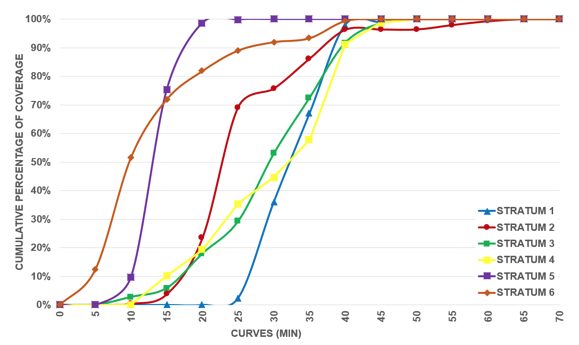
Figure 12 . Percentage of Stratum covered by Sancancio.
In Figure 13, The Integral Accessibility from the Shopping Malls is shown; the isochrones curves are calculated from 5 minutes (green color) to 55 minutes (red color) with intervals of 5 minutes. With regard to the spatial coverage to each stratum, Figure 14, shows the cumulative percentage of population covered by the isochrones curves. Overall, 50 % of people who live in Stratum 5 and 6 need between 5 and 10 minutes to be covered by all five Malls, whilst the others need more than 15 minutes. To sum up, the two main sectors of the city where the Malls are located, have different consumer’s targets. Lower strata have been induced by Fundadores and Parque Caldas, whereas wealthy people have been induced by Cable Plaza, Sancancio and Multicentro. Consequently people from higher strata have more access to this type of equipment than people from lower strata.
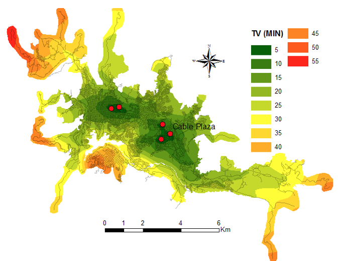
Figure 13 . Isochrones Curves from the Shopping Malls
-----
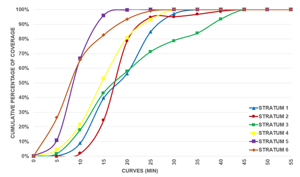
Figure 14 . Percentage of Stratum covered by all the Shopping Malls.
Geomarketing has a fundamental role to develop strategies to enhance the companies´ activities, and it has gained a recognition throughout the year. However this field needs to be investigated deeply, as consumers’ behaviors have changed in this technological era.
Companies might increase the efficiency of their consumer service, prioritizing the acquisition of new type of consumers of several sectors of a city, by reducing travel costs of the consumers, defining different policies of marketing based on spatial coverage, etcetera. Another aspect, is to analyze the company location and employees residences, which could enhance the productivity of the staff, reducing the travel time and travel costs simultaneously.
Bell R. R., Zabriskie N. B., (1978). Assisting Marketing Decisions by Computer Mapping: A Branch Banking Application, Journal of Marketing Research, 15, 1, 122-28.
Farrington, J. & Farrington, C. (2005). Rural accessibility, social inclusion and social justice: towards conceptualization. Journal of Transport Geography, 13 (1), 1-12.
Geurs, K., & Ritsema Van Eck, J. (2001). Accessibility Measures: Review and Applications. Evaluation of Accessibility Impacts of Land-use Transport Scenarios, and Related Social and Economic Impacts. [citado el 04 de 08 de 2011], de National Institute of Public Health and the Environment. Disponible en <http://www.rivm.nl/bibliotheek/rapporten/408505006.pdf>
Izquierdo, R (1994). Transportes. Un Enfoque Integral. Madrid: Servicio de publicaciones del Colegio de Ingenieros de Caminos, Canales y Puertos de Madrid.
Jones, K., Pearce, M., (1999). The Geography of Markets: Spatial Analysis for Retailers, Ivey Business Journal, 63, 3, 66-70.
Latour, P., Le Floc’h J., (2001). Géomarketing: principes, methods et applications, Editions dÓrganisation, Paris.
Linneker, B. (1997). Transport Infrastructure and Regional Economic Development in Europe: A Review of Theoretical and Methodological Approaches. University of Sheffield, Department of Town and Regional Planning.
McCarthy E. J., (1960). Basic Marketing: A Managerial Approach. (Editorial)Homewood, IL: Richard D. Irwin. INC
MacKinnon, D., Pirie, G., and Gather, M. (2008). Transport and economic development. In R. Knowles, J. Shaw, & I. Docherty, Editors, Transport Geographies: Mobilities, Flows and Spaces (p. 10-28). Blackwell Publishers, Oxford.
Plan de Movilidad para la ciudad de Manizales, 2010.
Ribeiro, A. and Silva, J., (2011). Space, development and accessibility between Portugal and Spain: the last frontier, Revista Portuguesa de Estudos Regionais, 27, pp.7-14.
Vickerman, R., Spiekermann, K. and Wegener, M., (1999). Accessibility and economic development in Europe, Regional Studies, Vol. 33(1), pp.1-15.
Rietveld, P. and Nikjamp, P., (1993). Transport and regional development. In: J. Polak and A. Heertje, Editors, European Transport Economics, European Conference of Ministers of Transport (ECMT), Blackwell Publishers, Oxford.
1. Universidad Nacional de Colombia, Faculty of Engineering and Arquitecture, Civil Engineering Department. Email: judzuluagaga@unal.edu.co
2. Universidad Nacional de Colombia, Faculty of Engineering and Arquitecture, Civil Engineering Department. Email: daescobarga@unal.edu.co